![]()
Logan and Albert Conservation Association
![]()

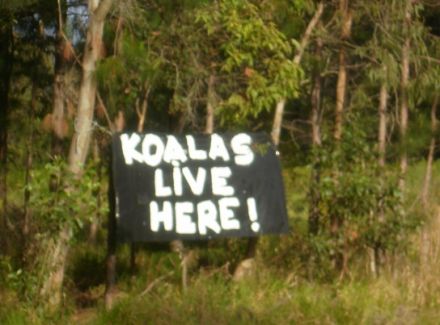
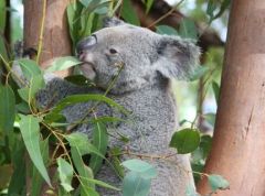 KOALAS are listed as Vulnerable in Queensland.
Anyone who has koala sightings ( dead or alive) from their property or from any suburbs or roads along or around the proposed Park Ridge Connector Route could you please email these sightings to Anne Page This email address is being protected from spambots. You need JavaScript enabled to view it.
Please include -
1. the approximate date of sighting ( or time of year and year) if possible
2. how many koalas you saw
3. a specific location ( eg street address number, street name, suburb name with post code )
4. what was the koala doing at the time you observed it?
Why report dead animals?
This is positive evidence of presense of animals in area - and easier to photograph.
Please take photos if you can.
There are areas along the proposed Park Ridge Connector Route that are listed under DERM (Department od Environment and Resource Management) mapping as Essential Habitat for Koalas.
On the internet go to - http://www.derm.qld.gov.au/property/mapping/mapsonline.html#wildlife_online
then select the link to State Koala Habitat Maps and enter your Lot on Plan for your property ( you can get this from your rate's notice).
There is other online mapping that you can also access on this same link e.g. remnant vegetation mapping, regrowth mapping and wildlife online. Just click on those links and use your lot on plan to send a request for an electronic map.
Koala State Planning Maps identify certain areas as high koala bushland, medium koala bushland and low koala bushland as well as areas suitable for rehabilitation for koala habitat.
There are very few areas in the Park Ridge Connector Route that were visited by DERM officers to do field survey checks to confirm koala habitat values for the Koala State Planning Maps, but two of them are close to the proposed PRC route
(a) Jerry's Downfall Reserve - medium value bushland
(b) a large site at the end of Virgil Rd that extends east and meets at the end of Dandaraga Ct - high value koala habitat at the end of Virgil Rd ( on east side) and medium value habitat on rest of block.
(c) a property on Hawkins Road ( Stockleigh) - high habitat value and medium habitat value
Under the State Koala Planning Policy development in koala habitat must be mitigated first - that means the proposed road corridor must first demonstrate that every effort has been made to AVOID koala habitat. Offsets are only a last resort when all other avenues have been explored.
Has Main Roads done this for the Park Ridge Connector Route?
There are concerns about the accuracy of the State Koala Planning Maps generally as very few sites were ground truthed, and the Australian Koala Foundation has their own koala mapping that they use. You can access the Australian Koala Website and enter your own koala sightings online https://www.savethekoala.com/koalamap.html
The biggest threat to koalas is the loss of habitat and habitat fragmentation.
 Extension is available for Park Ridge Connector Corridor feedback.
Today 18 November 2011 is still listed as closure for Park Ridge Connector Corridor feedback. However if you phone 1800 799 844 you will be granted an extension. This has come about because of community pressure. Ask for it in writing! Ask name of person granting this.
LACA has stated from the very beginning that there is no viable corridor however the wider community also MUST HAVE an opportunity to input into this process.
We believe that Main Roads are are now hearing that the community would feel disenfranchised if not given more time to make their reasoned submissions.
Please be aware that the feed back form attempts to channel your answers. Also note that the closely knit community of CHAMBERS FLAT is not even included in the feedback form.
LOOK OUT FOR A MEDIA RELEASE FROM MAINS ROADS Department of Transport and Mains Roads - although the transport components of public transport and active transport ( cycling and personal motorised disabilty scooters) are not included in any discussion
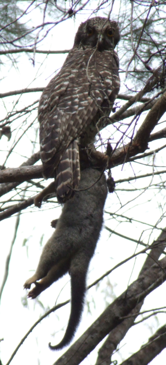
This powerful owl - captured on camera in Karawatha Forest this week - has bitten the head off the possum. The owl is a top predator in the proposed 'corridor of interest' and ranges over a large area. To survive he needs large intact bushland where his prey live and breed. Thus the survival of the owl depends on the possum which needs old growth trees with hollows. We need to protect corridors for wildlife rather than corridors for roads.
BARN Brisbane Area Rescue Network is an active WILDLIFE CARERS group rescuing and rehabillitating wildlife in western Logan. You woud be amazed at the number and range of animals needing assistance. They provide some great tips that we can all adopt to help reduce injuries, trauma and fatalities on their FACEBOOK page.
The list is by no means exhaustive or in a particular order and suggestions or ideas of what others are doing to help are welcomed.
New partnership for wildlife carers
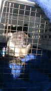 This koala was rescued on 5 October 2011, and taken to Daisy Hill Koala Sanctuary. He was euthanased at Moggil Hospital due to his being blind (from having had conjunctivitus and cystitis) and not having a suitable habitat to be released. He was 6 years old. Apparently if his habitat was denser he would be fine to survive as they usually rely mainly on smell and hearing (in a koala with normal sight). They do release koala's that are blind.
Image aside is one of the photos of the koala "rescued" by a local wildlife carer.
The new partnership between DERM and RSPCA ,Qld and the carer network would strengthen the overall care of wildlife in Queensland by combining resources and providing a united approach. RSPCA Qld and DERM have driven this change to improve coordination and response times, and reduce the time that animals are in distress according to Mr Bradley from RSPCA
The change to 1300 ANIMAL means the caller will speak directly to an experienced RSPCA Qld operator who will arrange an appropriate response. The partnership covered various aspects of the management and regulation of protected wildlife rescue, care and rehabilitation.
The new arrangements will be trialed for 12 months from 1 September, and DERM has contributed $60,000 to support the improved response and the RSPCA's package of improved networking, training and communication for the wildlife carer network. DERM will still be responsible for issuing wildlife rehabilitation permits.
The care and rehabilitation of sick, injured and orphaned wildlife is delivered through a dedicated volunteer network of licensed wildlife carers throughout Queensland. RSPC Qld currently has approximately 400 'wildlife heroes' who are available to conduct the rescue of sick, injured or orphaned animals and who support wildlife carers and that number is set to increase following a recruitment drive.
DERM ensures that wildlife care is done according to best practice and meets the expectations of the broader community through a Code of Practice for carers.
Read that code here. I have some reservations about the code. Hopefully there will be an open review after 12 month trial period.
You can see the presentation delivered to wildlife carers here. New partnership for wildlife care information is here
The greatest threat to our local koalas in the LACK OF POLITICAL WILL TO CREATE LEGISLATION TO PROTECT THEIR HABITAT.
Second PUBLIC MEETING 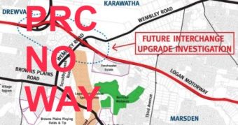 @
@
LOGAN RESERVE SCHOOL School Rd
PUBLIC PROTEST MEETING - NO PRC
TUESDAY 15 NOVEMBER 2011
7pm
Logan Reserve School in new assembly hall
Contact Karen 3802 2353, Rod 0408 740 144 or Anne 3297 0624 for more details and contributions to meeting.
Come along to add further support to opposing the proposed road. Our united and voiced opposition will stop this project and send government back to the drawing board.
SIGN PETITION TO LOGAN CITY COUNCIL
COLLECT SAMPLE LETTERS TO STATE MINISTERS FOR ROADS AND ENVIRONMENT.
JOIN THE CAMPAIGN TEAM TO STOP THIS PROPOSED TOLLWAY
ADD YOUR SKILLS TO THE CAMPAIGN
Thank you to all the folk who came along and contributed to the process.
We need to show - bu our actions - that process of consultation is flawed.
 The Logan and Albert Conservation Association (LACA) does not support the use of critical ecosystems and habitat, wetland areas or areas of biodiversity for transport infrastructure corridors.
LACA does not support the degradation or loss of habitat, wetlands, biodiversity, or ecological corridors. For these reasons, LACA does not support any road corridor or any other infrastructure corridor that would degrade and remove the biodiversity, habitat or ecosystem functions and services for the area between the Logan Motorway and the Logan River.
LACA recognizes the value of protecting critical habitats, ecosystems, wetlands, riparian areas and biodiversity assets such as those at Karawatha Forest, Berrinba, 'Rosicrucian' land, Scrubby Creek, habitat that remains south of the Logan Motorway, Jerry's Downfall Reserve, Chambers Creek and the Logan River and its tributaries.
Calculation of the potential future carbon footrprint and offset now and in the future and providing this information to the community for accountability is essential to evaluate viability.
Investment in developing a SUSTAINABLE TRANSPORT PLAN which will reduce need to construct any further roads for motor vehicles including public transport options, comprehensive bicycle / motorized scooters/wheelchair lanes and independent mobility devices for disabled should be considered as a viable alternative to new motorways.
Globally many countries are applying The Economics of Ecosystems and Biodiversity [TEEB] PRINCIPLES to account for real cost of exploitation of natural environment for built infrastructure. These reports are available at www.teebweb.org. Our local and state governments would find these useful tools for evaluating loss of biodiversity and ecosystem services.
As a member of the CSRG LACA submitted OUR ENVIRONMENTAL VALUES. See them here. environmental_values_LACA_PARK_RIDGE_CONNECTOR_ROAD.pdf 142.99 Kb 05/11/2011, 12:54
 I speak for the trees for the trees have no tongues
- The Lorax, Dr Seuss
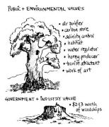
Have you ever looked at trees and thought they just stand there and do nothing? It may seem that way, but in fact they are very busy doing a mixture of jobs that are really important.
What they are doing can be described as ecosystem services. Animal houses, air, rain and shade makers (If trees didn't breathe, neither could we. The health of our air, soil and water all relies on trees to keep it clean.) and even dead trees play an important role. Fallen trees provide shelter and food for many animals. See
http://www.acfonline.org.au/articles/news.asp?news_id=3459 to read more
PUBLIC MEETING @ PARK RIDGE PUBLIC MEETING @ PARK RIDGE PUBLIC MEETING @ PARK RIDGE
TUESDAY 8 NOVEMBER 2011
7pm
Park Ridge (Baptist) Church Main Hall
3922 Mt Lindesay Highway Park Ridge 4125
(Take the exit off highway at Park Ridge and follow the eastern service lane for the Mt Lindesay Highway – brick building with car park area provided)
NO LOSS OF BIODIVERSITY IS VIABLE
We want koalas not new tollways. We want quolls not more multi-lane roads. Bushland habitat is home to many native wildlife and wetland areas like Jerry's Downfall which is part of Chambers Creek Catchment Area provide critical filtering system for the rivers and creeks of Logan.
Bushlands wetlands and river systems all contribute to those essentials to maintain human life - clean air, clean water and food. Sustainable development, meaning ecologically sustainable, requires that our human settlement - and moving around - does not destroy the natural envionment to introduce more built structures.
COME TO THE PUBLIC MEETING TUESDAY 8 NOVEMBER 2011 @ PARK RIDGE @ 7pm - SAME VENUE PRC INFO SESSIONS
Contact Karen 3802 2353 , Rod 0408 740 144 or Anne 3297 0624 for more details and contributions to meeting.
See STANDING AGAINST HIGHWAY
 PARK RIDGE CONNECTOR ROAD
– Dividing Communities and Environments
Residents from Browns Plains to Chambers Flat who have concerns or want to know more information about the proposed Park Ridge Connector Road / Corridor are encouraged to attend a residents meeting -
WHEN – Tuesday 8 November from 7 pm
WHERE – Park Ridge Baptist Church Main Hall
3922 Mt Lindesay Highway Park Ridge 4125 (Take the exit off highway at Park Ridge and follow the eastern service lane for the Mt Lindesay Highway – brick building with car park area )
For more information contact Anne ( ph 3297 0624 ).
The final route is yet undecided and whatever is decided will shape the future of the local area we all live in with impacts on residents' lives and homes, businesses, local communities and the environmental assets that we all value.
Comments to Main Roads close 18 November.
Main Roads is proposing an 8 km corridor to be approximately 100 metres wide and it is proposed to initially be a heavy freight route that may extend from the Logan Motorway to Granger Rd at present. The current options out for consultation include future provisions to extend to Chambers Flat and further south.
BE A PART OF THE SOLUTION NOT PART OF THE PROBLEM
– support your neighbours, communities and the environment we value by attending this meeting.
Together we can have a BIGGER voice.
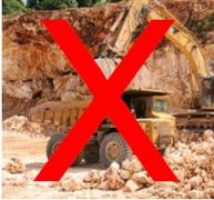 Quarry Action Group - Cryna quarry expansion
Friday 4 November is the last day to object to the expansion of the Cryna quarry. Linked letter may help you with the formalities of lodging your objection. List the reasons that concern you in your objection.
If you live south of Beaudesert and travel on the Mt Lindesay Highway you will share the road with all of the quarry traffic. If your children or grandchildren go to St Mary's they will be affected by the increased traffic. Much of the extra heavy vehicle traffic generated will disperse northbound so Beaudesert and other little towns in the area will all have an increase in traffic. The many objections to the Mega Quarry proposed in Kerry Valley are also applicable.
Download a letter template you can adapt to express your concerns here.
 Cryna_Quarry_Objection_sample.doc 62.50 Kb 30/10/2011, 16:59
Please also visit group website here where you can read aome amazing breaking news which we believe should establish a president for quarry traffic on roads. http://www.quarryactiongroup.org.au/files/CourtDecision.pdf and http://www.quarryactiongroup.org.au/files/SRRCLetter.pdf
A Quarry Action Group traffic study was very scathing of the developers assessment as the developer's report used old traffic data and gave little attention to improving the road to makeit safe for this level of traffic. A full copy of the traffic study can be found by clicking this link. http://www.quarryactiongroup.org.au/files/TrafficStudy.pdf